标签: 优质分享
- 作者帖子

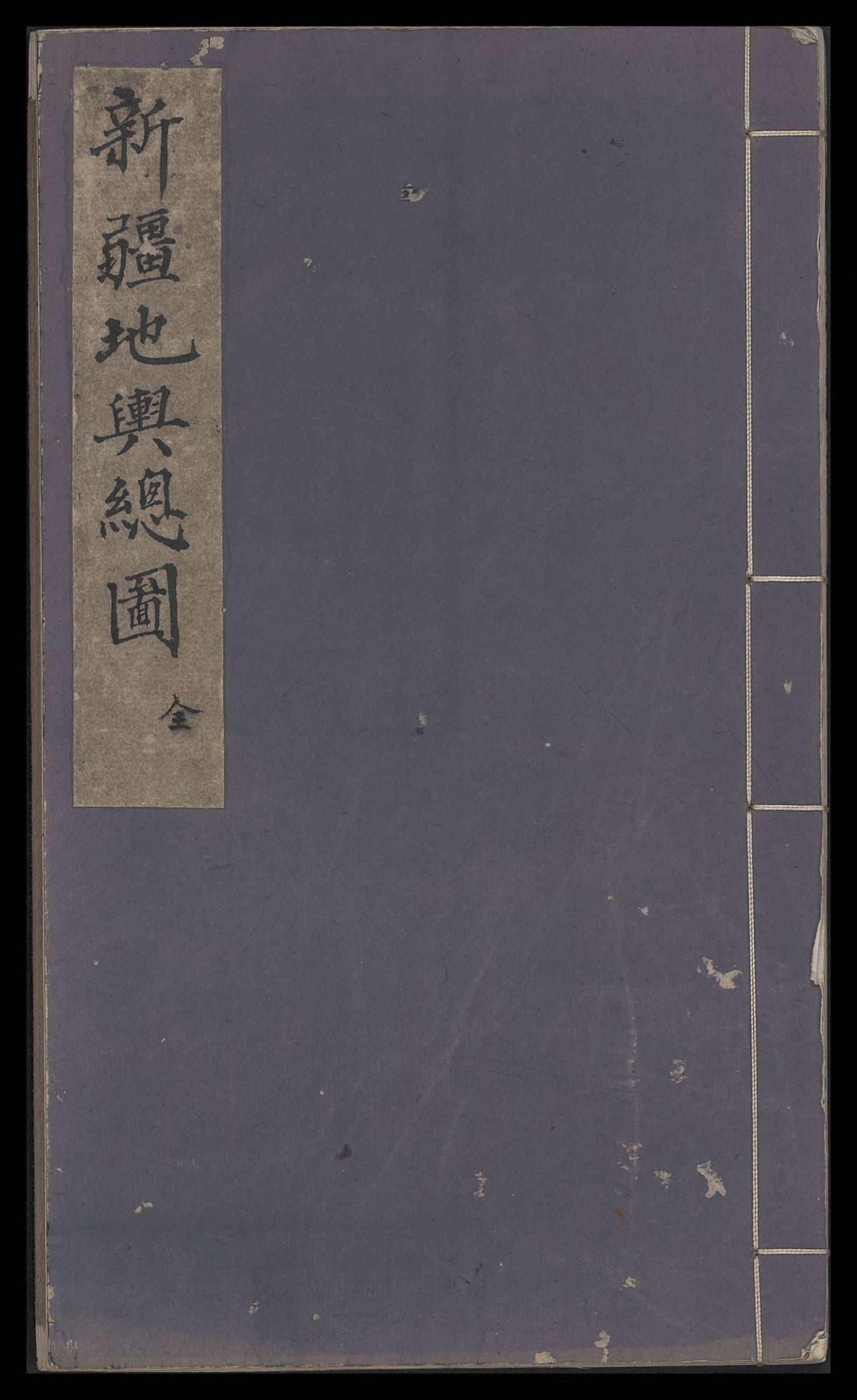
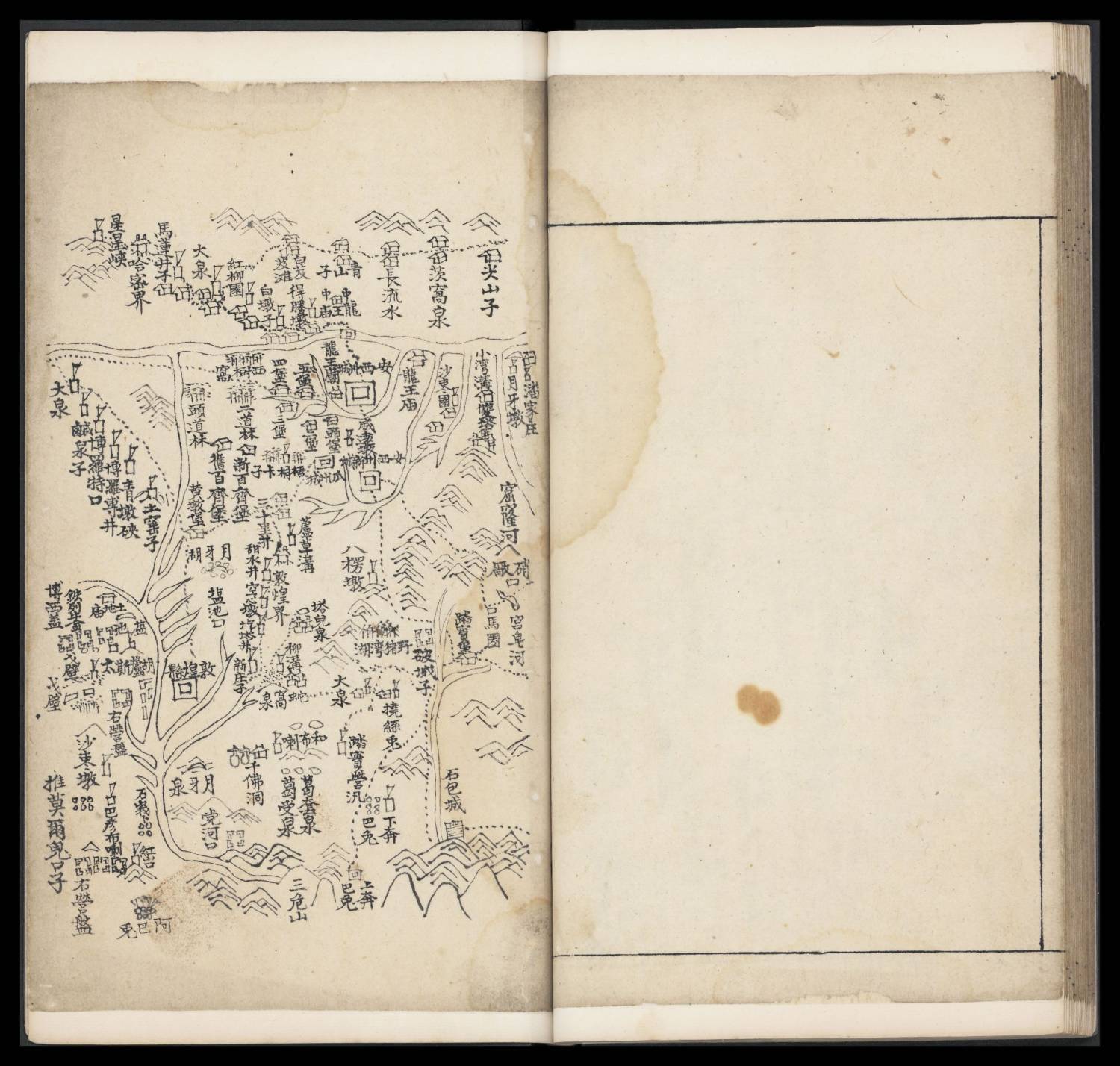
guozibaba游客新疆地舆总图.图18幅.纸本墨绘.光绪年间写本.台北”国家图书馆“藏
来源:美国国会wdl
理由:对新疆地图较为感兴趣,里面有熟悉的地名。感兴趣的下。
介绍:王耀.台北“国家图书馆”藏清代《新疆地舆总图》研究[J].中国典籍与文化,2014,(第3期).
台北“国家图书馆”对于该图的著录内容极少,仅给出版次、版本类型等信息。据其著录,该图为纸本墨绘,边框长宽为18.1厘米×13.5厘米,光绪年间写本,未就具体图幅内容给出注解。
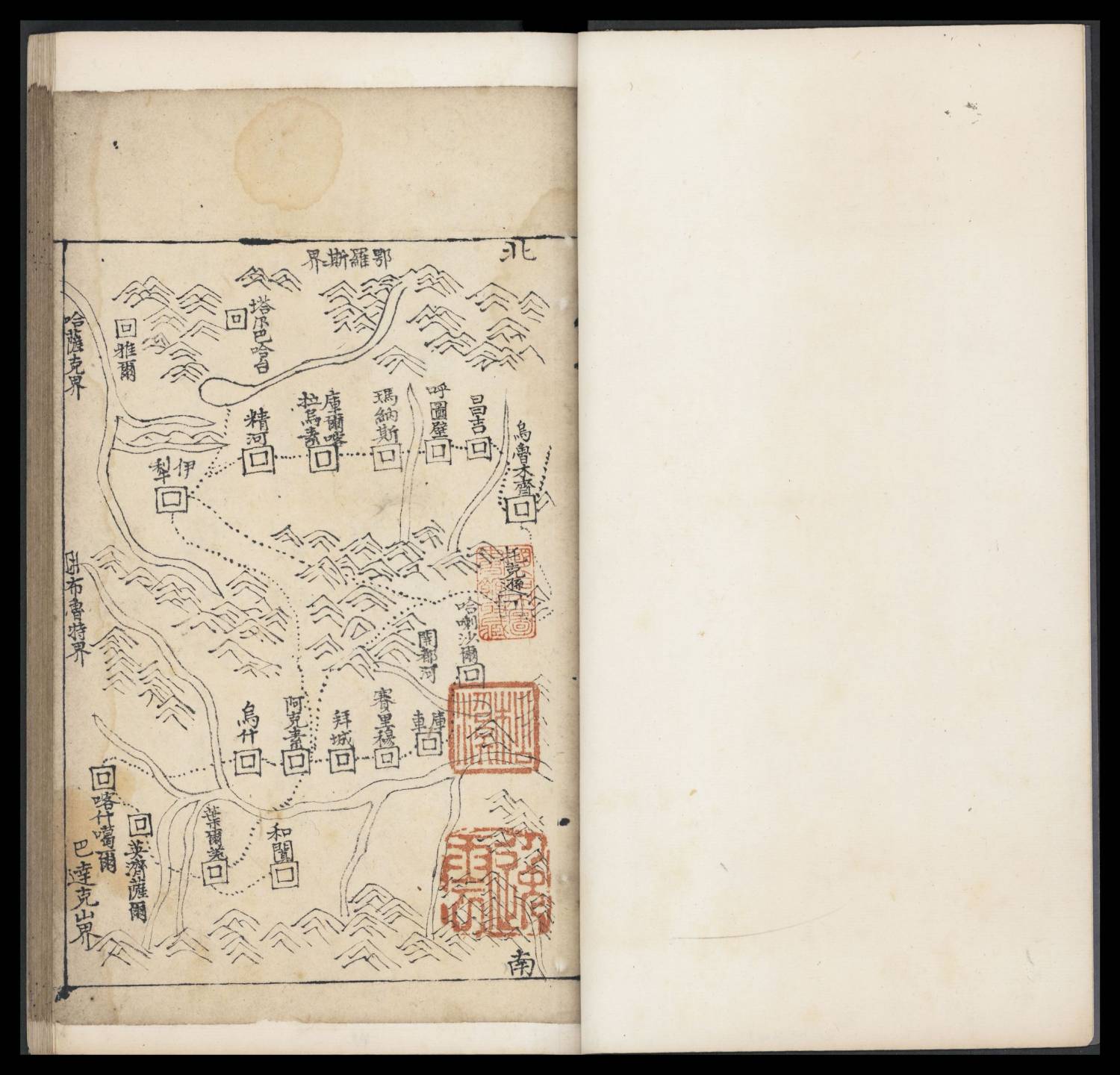
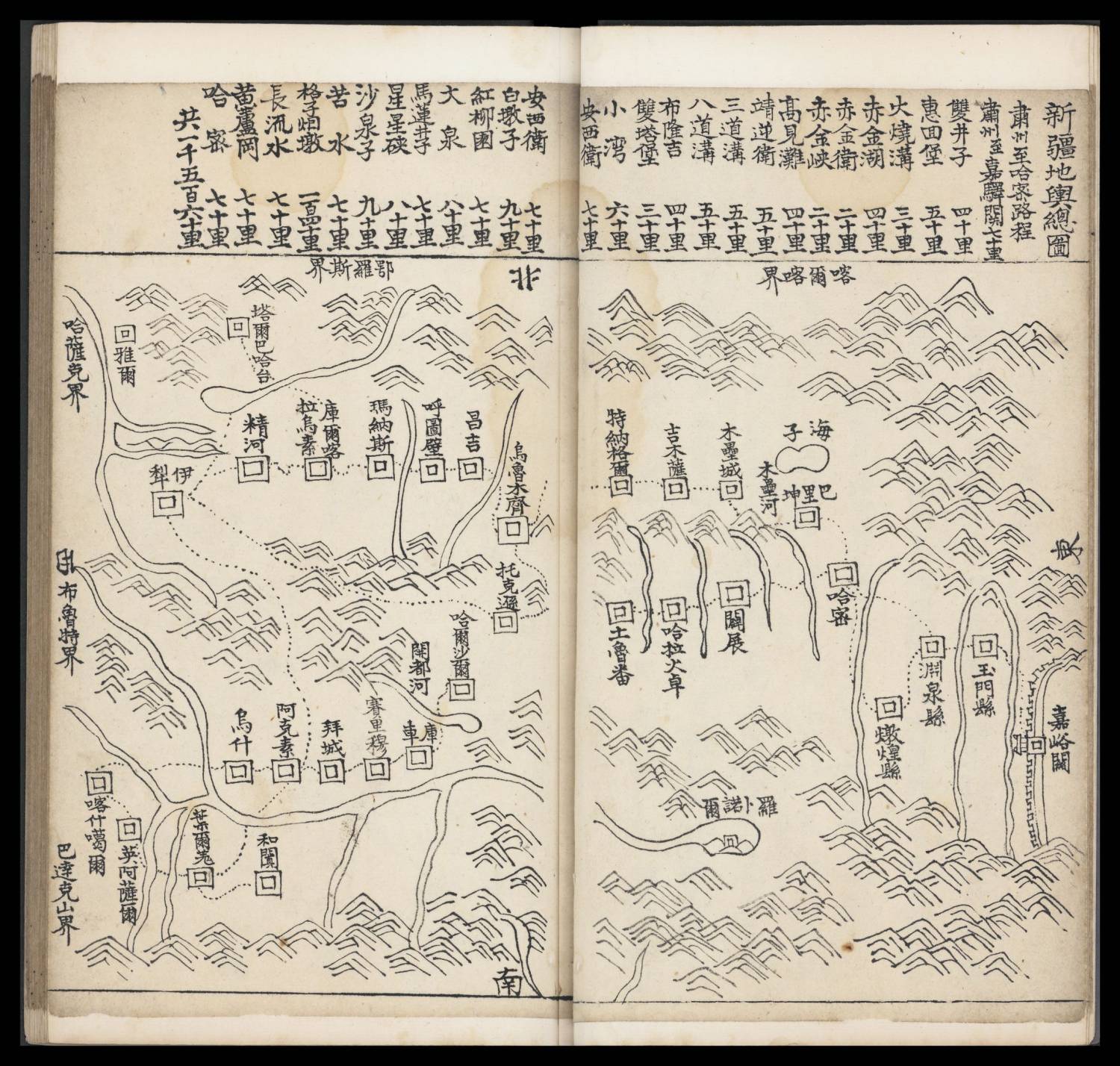
该图为册装,纸本墨绘,共有图18幅,每幅图均标注方位,为上北下南。图幅内主要绘制新疆地区的山川、河流等自然景观和城市、驿路、台站、寺庙等人文景观,同时表现上述两者的相对空间关系。
其中,总图涵盖东起嘉峪关、西至伊犁、北达塔尔巴哈台、南至和阗的整个新疆地区。其他各图分区域、分城市绘制,依次分别绘制了玉门县与敦煌县、哈密新城与回城、巴里坤城、奇台城、迪化满城与汉城、伊犁地区的惠宁城、惠远城、宁远城与绥定城、辟展与吐鲁番城、哈拉沙尔、库车、赛里木与拜城、阿克苏城、永宁城、和阗、叶尔羌、喀什噶尔旧城与徕宁城等区域。
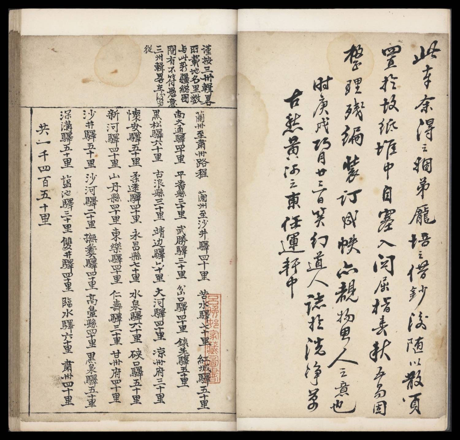
据台北“国家图书馆”著录,该图刻书年/出版年为清光绪,并未给出具体判定依据。该图中有一段文字,誊录于此:“此本余得之姻弟庞培之,借抄后,随以散页置于故纸堆中。自塞入关,屈指春秋五易,固整理残编装订成帙,亦睹物思人之意也。时庚戌巧月廿三日,笑幻道人志于洗净万古愁黄河之东任运轩中。”由此可知,该图由笑幻道人抄绘,该人为何人、有何经历,惜未查到相关信息。另外,清中后期的乾隆五十年(1790)、道光三十年(1850)、宣统二年(1910)均为“庚戌”年,难以判定该图具体抄绘于何时。
就《新疆全图》的绘制时间而言,因为该图不具撰人,且图幅中没有任何文字著录,所以很难推断绘制时间。而表现年代方面,因为《新疆全图》与《新疆地舆总图》所表现的各类地名、建置信息基本一致,所以同样推定《新疆全图》图幅内容反映的极大可能是乾隆三十八年的状况,具有较高史料价值。
综观全文而言,台北“国家图书馆”藏《新疆地舆总图》是形象化表现清乾隆中期新疆状况的为数不多的可靠图像史料,应发挥其“以图证史”的作用,重视其图像资料的价值。
书影:

链接: pan.baidu.com/s/1Pz...Q?pwd=mapc 提取码: mapc
tenghu游客感谢分享
xiaopengyou游客感謝分享
但美國國會圖著錄:
This work is a hand-painted atlas of Xinjiang. The atlas is small, with frames of different sizes. There are no prefaces or postscripts, and the identity of the map maker is unknown. The atlas is executed in the traditional landscape-painting style and does not provide degrees of longitude and latitude, nor scales. Towns, rivers, lakes, and mountains are all depicted in their approximate locations. Each map covers one double-page spread. The four directions from the east to the north are marked, but the boundary lines of cities and towns are not drawn. At the front is an overview map of Xinjiang, which is followed by a map of Anxi Zhou, an area bordering present-day southern Gansu, southeastern Qinghai, and northwestern Sichuan. Anxi Zhou is the western half of the historical Hexi Corridor route, which crosses Xingxing Xia (The Gorge of the Stars) to enter Xinjiang. The third map depicts Hami, and is followed by maps of Balikun, Qitai, Dihua, Yili, Pizhan and Turfan, Harsar, Kuche, Salim and Baicheng, Aksuo, Yongning, Ye'erqiang, Hetian, and Kashgar. In all there are 16 maps in the atlas. There are no textual explanations, except for a note on the introductory map describing the route from Suzhou to Hami and listing 27 post stages on the route and their distances, and a note at the head of the Anxi map describing 12 post stages and the distances between them. The map of Yili clearly depicts the borders with present-day Kazakhstan, reaching far north of Lake Zaysan and Lake Balkhash. The entire area of Yili River is shown as located within the territory of China, which indicates that the atlas was probably printed during the Qianlong and Jiaqing reigns of the Qing dynasty (1736--1820).
機器人翻譯:
這幅作品是一本手繪的新疆地圖集。圖集很小,有不同大小的框架。無序跋,製圖者身分不明。地圖集採用傳統風景畫風格繪製,沒有提供經緯度和比例尺。城鎮、河流、湖泊和山脈都按其大致位置進行了描繪。每張地圖都佔一頁雙頁。標示了從東到北的四個方向,但沒有畫出城鎮的邊界線。正面為新疆概況圖,其後為安西州地圖,安西州與今甘肅南部、青海東南部和四川西北部接壤。安西洲是歷史上河西走廊路線的西半部,穿越星星峽進入新疆。第三幅地圖是哈密,其次是巴里坤、奇台、迪化、伊犁、皮站、吐魯番、哈爾薩爾、庫車、薩里木、白城、阿克索、永寧、葉爾羌、和田、喀什。地圖集中共有 16 張地圖。沒有任何文字解釋,只是在介紹地圖上註明了從蘇州到哈密的路線並列出了路線上的27個驛站及其距離,以及在安西地圖的頭部註釋了12個驛站及其距離它們之間。伊犁地圖清楚地描繪了與現在的哈薩克的邊界,一直延伸到宰桑湖和巴爾喀什湖以北。整個伊犁河地區都位於中國境內,這表明該地圖集很可能是在清朝乾隆嘉慶年間(1736--1820)印製的。
似乎美國國會圖因“整個伊犁河地區都位於中國境內”,從而認定這地圖集可能出版於清朝乾隆嘉慶年間(1736--1820)?
anheqiao游客新疆地舆总图.图18幅.纸本墨绘.光绪年间写本.台北”国家图书馆“藏
来源:美国国会wdl
理由:对新疆地图较为感兴趣,里面有熟悉的地名。感兴趣的下。
介绍:王耀.台北“国家图书馆”藏清代《新疆地舆总图》研究[J].中国典籍与文化,2014,(第3期).
台北“国家图书馆”对于该图的著录内容极少,仅给出版次、版本类型等信息。据其著录,该图为纸本墨绘,边框长宽为18.1厘米×13.5厘米,光绪年间写本,未就具体图幅内容给出注解。
该图为册装,纸本墨绘,共有图18幅,每幅图均标注方位,为上北下南。图幅内主要绘制新疆地区的山川、河流等自然景观和城市、驿路、台站、寺庙等人文景观,同时表现上述两者的相对空间关系。
其中,总图涵盖东起嘉峪关、西至伊犁、北达塔尔巴哈台、南至和阗的整个新疆地区。其他各图分区域、分城市绘制,依次分别绘制了玉门县与敦煌县、哈密新城与回城、巴里坤城、奇台城、迪化满城与汉城、伊犁地区的惠宁城、惠远城、宁远城与绥定城、辟展与吐鲁番城、哈拉沙尔、库车、赛里木与拜城、阿克苏城、永宁城、和阗、叶尔羌、喀什噶尔旧城与徕宁城等区域。
据台北“国家图书馆”著录,该图刻书年/出版年为清光绪,并未给出具体判定依据。该图中有一段文字,誊录于此:“此本余得之姻弟庞培之,借抄后,随以散页置于故纸堆中。自塞入关,屈指春秋五易,固整理残编装订成帙,亦睹物思人之意也。时庚戌巧月廿三日,笑幻道人志于洗净万古愁黄河之东任运轩中。”由此可知,该图由笑幻道人抄绘,该人为何人、有何经历,惜未查到相关信息。另外,清中后期的乾隆五十年(1790)、道光三十年(1850)、宣统二年(1910)均为“庚戌”年,难以判定该图具体抄绘于何时。
就《新疆全图》的绘制时间而言,因为该图不具撰人,且图幅中没有任何文字著录,所以很难推断绘制时间。而表现年代方面,因为《新疆全图》与《新疆地舆总图》所表现的各类地名、建置信息基本一致,所以同样推定《新疆全图》图幅内容反映的极大可能是乾隆三十八年的状况,具有较高史料价值。
综观全文而言,台北“国家图书馆”藏《新疆地舆总图》是形象化表现清乾隆中期新疆状况的为数不多的可靠图像史料,应发挥其“以图证史”的作用,重视其图像资料的价值。
感谢分享
chenggong游客谢谢
- 作者帖子